




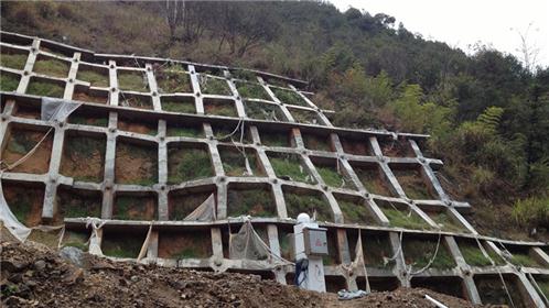
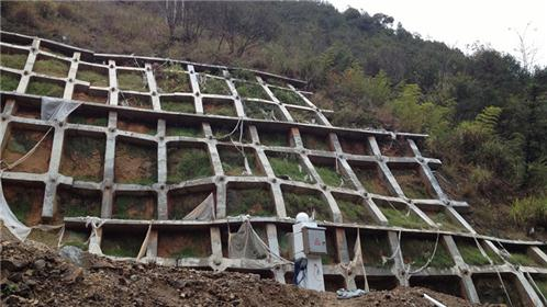
The Ningwu Expressway has a total length of 203 kilometers and construction began at the end of July 2012. It is the first horizontal highway in the "Three Verticals, Eight Horizontals, Three Rings, and Thirty Three Connections" plan of the main highway network in the Economic Zone on the west coast of the Taiwan Strait. It is also a highway project with a long construction mileage, high investment, complex terrain, and difficult engineering in a single prefecture level city in Fujian Province. After excavation of the left high slope of a section of Ningwu Expressway, the third and fourth grade slopes are fully weathered quartz schist; After excavation and layout of the left slope based on the actual measured ground line, the actual excavation slope increased by two levels compared to the original design. The current slope has a total of 9 levels, totaling 80m, which is an ultra-high slope.
The slope safety automation monitoring system adopts an overall design and sub implementation architecture mode, including surface displacement monitoring subsystem, deep monitoring subsystem, environmental monitoring subsystem, stress monitoring subsystem, video inspection monitoring subsystem, lightning protection and power supply system, communication system, and monitoring center system. The data collection terminals of all subsystems - front-end data processors - are arrangedin the slope monitoring area to collect real-time data information from various monitoring stations online; The communication mode between the duty room and the slope data terminal is wired fiber optic and wireless GPRS. The monitoring center system is located in the provincial high command duty room and is used for real-time automatic data collection, analysis, display, comprehensive warning, data storage, and web data publishing. The expressway administration and even the government safety supervision department can access the monitoring system through the Internet to view and analyze the running state of the slope in real time, and control the monitoring system after authorization.
Instruments and meters used in slope monitoring

Monitoring Implementation Function
1. It has the functions of automatic collection, transmission, storage, processing, analysis, and comprehensive warning of slope operation data, and can be monitored in real-time 24/7 under various climatic conditions;
2. It has functions such as basic data management, real-time display and publishing of various monitoring contents, graphic report production, data analysis, comprehensive warning, manual observation and input, lightning protection, anti-interference, data backup, power failure protection, self diagnosis, and fault display;
3. The system monitoring platform has professionalism and integration, slope video monitoring and intelligent analysis, and optimized design; Equipped with three-level networking and alarm functions at the city, county, and mine levels; The system software has interfaces that support and display the monitoring platform of the Safety Supervision and Administration Bureau; Monitoring room terminal display.